A blanket of cloud had come down low to meet the tops of the mountains north of Antigua, Guatemala. At the side of the road I saw Mayans in shawls and ponchos, their kids in bobble hats. Some had started fires on the verge to warm their hands. Everyone walked with purpose.
The driver of the minibus to Guatemala City was careful and safety-minded. He slowed down on the tighter bends, used his gears to manage the steeper descents, and whistled meaningfully when two brightly painted buses shot by, one appearing to take a corner on two wheels.
I had a seat up front. I asked him why the chicken buses – the gringo nickname for the converted US school buses that dash around Guatemala – went so fast?
“They’re competing for passengers,” he said. “They each want to get to the next stop first so they can collect the fare.”
“Are there ever accidents?” I asked.
“Oh, lots,” he said. “They come off the road and fall down cliffs, they turn upside down, they crash head on.”
He said this as if it was a neutral observation. The rest of the time we chatted about the road improvements. The driver said the Taiwanese were responsible for the widening and landscaping of the highway, which was constantly beset by landslides during the rainy season.
A little later we noticed that one of the chicken buses had pulled over. Presumably it was the leader of the race. And of course, the loser had raced past to get to the next stop first. All for a few quetzals. It seemed like a rather absurd way to run public transport.
Then, we turned a corner, the clouds parted and there was a volcano – a mighty cone not 35km from the highway. It was Pacaya, smoking, still very much alive. A hiker in Antigua had told me you could feel the earth was hot beneath your feet in some places. “Have you climbed it?” I asked the driver. He laughed. “No way, too risky,” he said. “But not as risky as Guatemala City, where I’m dropping you off.”
Danger and death, geopolitics and geology, economic reality and natural beauty – nothing opens up a country like a road trip.
The first leg, through the Guatemalan highlands, was a classic Latin American combination of distant drama – not only Pacaya but the even more impressive Agua and Fuego volcanoes – and chaotic, colourful towns hugging the roadside. Densely forested mountains and rich farmlands filled the spaces in between.
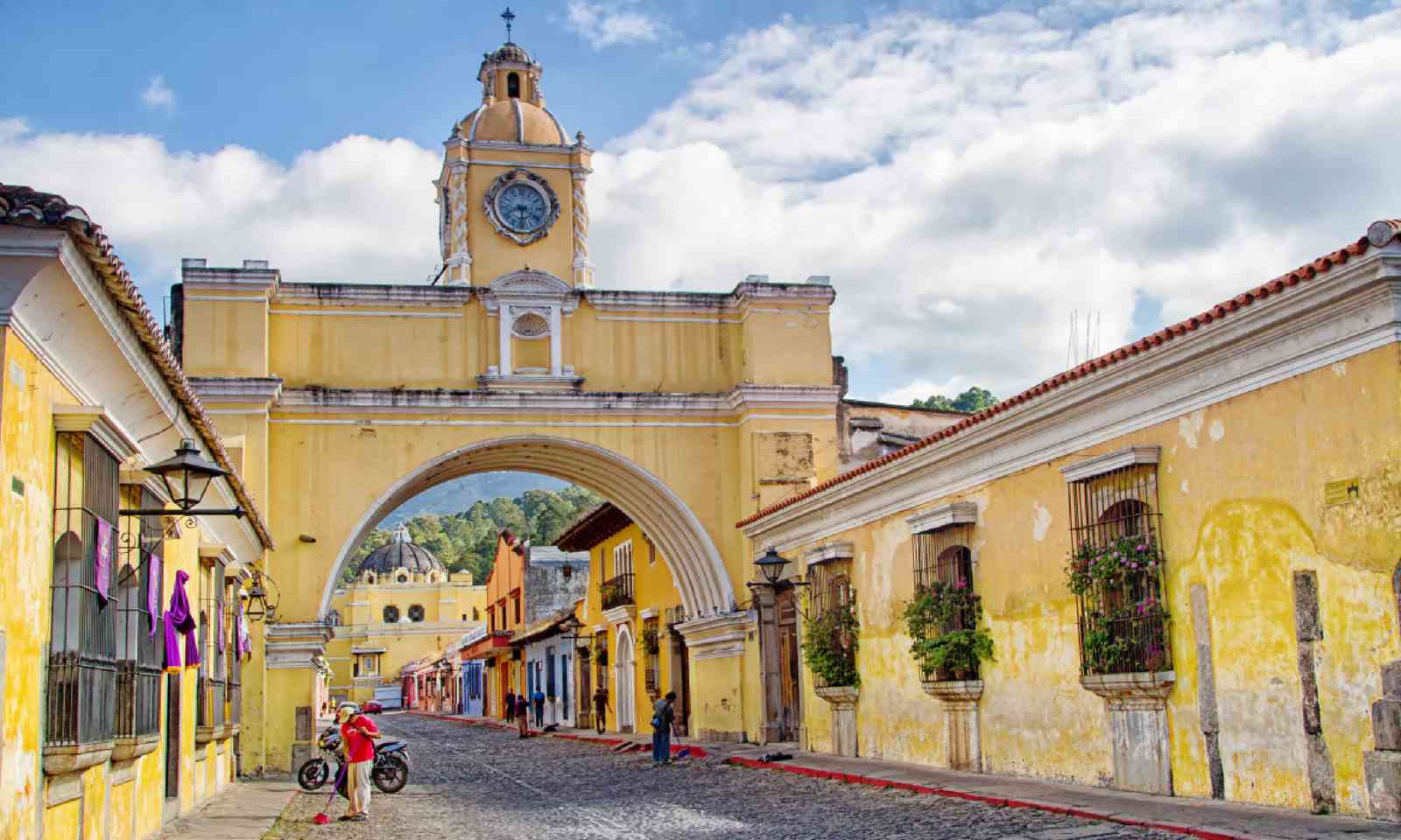
Colourful colonial buildings in Antigua, Guatemala (Shutterstock)
Soon I was deep inside the sprawl of Guatemala City, an ideal place to see through a bus window. Drab suburbs and manic markets can fascinate at a safe remove. At the main terminal I hopped on a bus heading south through a region cultivated with maize, wheat, coffee and sugarcane plantations. Barberena and Cuilapa looked like thriving agricultural towns, farmers trucks coming and going, street vendors jostling for space. Tourism so often thrusts travellers into curated places, but being on the road you see the lot.
The highway was heavy with lorries carrying fuel, food, scrap metal for recycling, cattle. Because everyone works along or just off this road, the soft-shoulders and verges were throbbing with men carrying machetes and coffee beans, fruit stalls, coconut vendors, school kids, bicycles and tuk-tuks, pickups and even the odd donkey. I saw some men selling live iguanas, illegally, holding the panic-stricken lizards by their tails.
I had a private guide in El Salvador, and a chance to see a bit more of the country. We spent a night at El Imposible, a national park named for its terrifying chasm, down which passing pack animals and muleteers would frequently fall to their certain death. I went birding at dusk and dawn and saw a mottled owl and a rare white hawk, before rejoining the highway to the capital.
San Salvador was a sprawl of a city, visibly Americanised in its layout, fast-food outlets and strip malls. I saw the huge mural in front of the main gallery, known as the Monument to the Revolution, commemorating the 1948 uprising that toppled President Salvador Castaneda Castro. With the Quetzaltepec volcano looming above, it was a dramatic enough setting – but I don’t go to Latin America for Burger Kings.
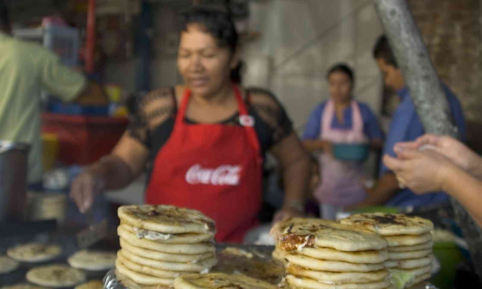
Street food in El Salvador (Shutterstock)
Suchitoto was far more my size of city. It has plenty of colonial buildings, and the plaza was a busy social spot with a funfair by day and fireworks at night. After a few beers, I watched as local men ran around wearing horse-shaped frames that were adorned with rockets and Catherine wheels. They chased girls and kids and basically ‘shot’ them with small explosives. It was hilarious – in a ‘this-could-go-horribly-wrong’ sort of way.
With my guide, we re-joined the Panamericana for the five-hour ride to Perquín, the operational base of many of the guerrillas who fought in the Civil War of 1979-1992. All Central America’s countries have seen strife of one kind or another, but El Salvador lost as many as 80,000 people in its proxy war. The village of El Mozote, in the north-eastern highlands of the country, was the site of the worst single massacre of the civil war. Some 1,000 civilians were killed, and only 450 or so have been accounted for; many of the slain were children.
I happened to be in town for the interment of some recently discovered remains. The procession was moving and there were moments of real beauty, with folksong, a children’s choir, and some uncompromising words from a local priest.
The land seemed to open out wondrously in Nicaragua. Here the volcanoes were far away and huge tracts of dead-flat farmland flanked the roadside. Tobacco, banana, sorghum and pineapple were planted everywhere; people dried coffee beans out on the pavement or even the road – traffic is rarely heavy off the main highway.
On Ometepe, an island in Lake Nicaragua, I got to taste the spoils – and it was the most aromatic cup of coffee I’ve ever woken up to. It powered me up a serious hike, a real knee-wobbler up a rocky track to the top of the Maderas volcano. Sadly it was cloudy on top, but there were dozens of hummingbirds whistling around the cool mist to compensate.
Staying at an ecolodge lower down the slopes, I had time to reflect. I was loving my drives and rides in buses and taxis and rented cars. But why? What is it about roads, especially long ones? The USA invented the road movie but Central America has as much right to own the idea now. Its roads run through wilder places; its iconography is still waiting to be deciphered. Settlement across Latin America, from farms to fruit stalls to gas stations, has largely been along the roadside.
If you want leisure, then head for the parks. But if you like to see real life, then spend some time on the road.
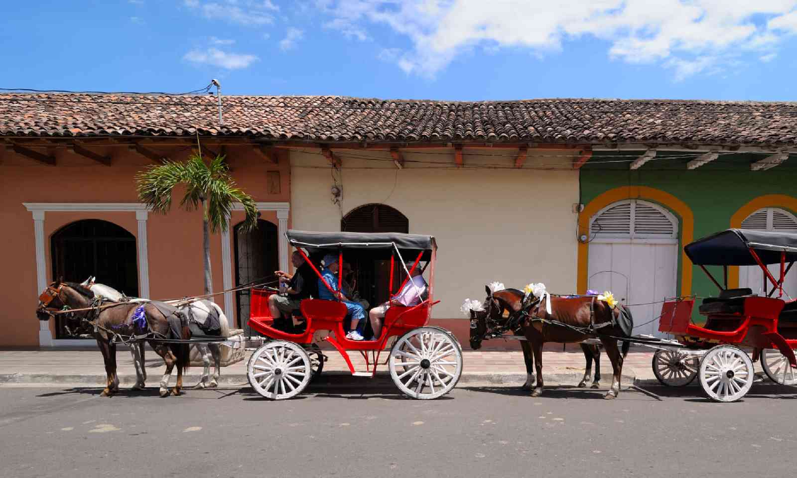
Horse carts in Granada, Nicaragua (Shutterstock)
My next drives took me to Nicaragua’s three main cities. Managua has the greenery – a pretty if sad consequence of the 1972 earthquake that razed the city – but León and Granada are the two essential stops.
Both cities boast old, low-slung architecture and are rich in history. León is proud of its revolutionary connections, and murals cover the city. Here, church bells ring over idealised images of beret-sporting Sandinista guerrillas and anti-American slogans.
Granada, to the south, is quainter, with the lake lapping its edges. I was struck by the happy mix of language students and old timers, and the central plaza was crazily busy with fiestas, street-food vendors, musicians, marches, cyclists and nuns – the cathedral was being consecrated and bishops from all over were in town for the big occasion.
Journeying out to some islets in Lake Nicaragua, I had my first total disconnection. No roads, no noise, no tourists, no plaza. I swam in the lake – reassured that the local sharks never came to the shallows – and dined on exquisite ceviches and fish dishes in a remarkable hotel built partly from the rescued remnants of 1998’s devastating Hurricane Mitch.
A lot of tourism in Costa Rica focuses on the two coasts. The Panamericana takes you through the heart of the country, where you’re as likely to explore human culture as that of birds and beasts. At the Rincón de la Vieja National Park I had a great day out with a vaquero (cowboy). We rode across the slopes of the park’s namesake volcano, which was wrapped in a dense forest and topped by threatening rain clouds. Under the pre-storm light the vegetation glowed a strange lime green.
Back on the road, distances between stops were quite small but steep climbs and switchbacks slowed things down. I detoured from the main route to stay at another volcano – Arenal – where I hired a bike to cycle on an easy track at its base before speeding up to get to some hot springs before nightfall. I could see bright-orange lava flows at the top of the volcano from my lodge, at least until a massive storm lit up the sky.
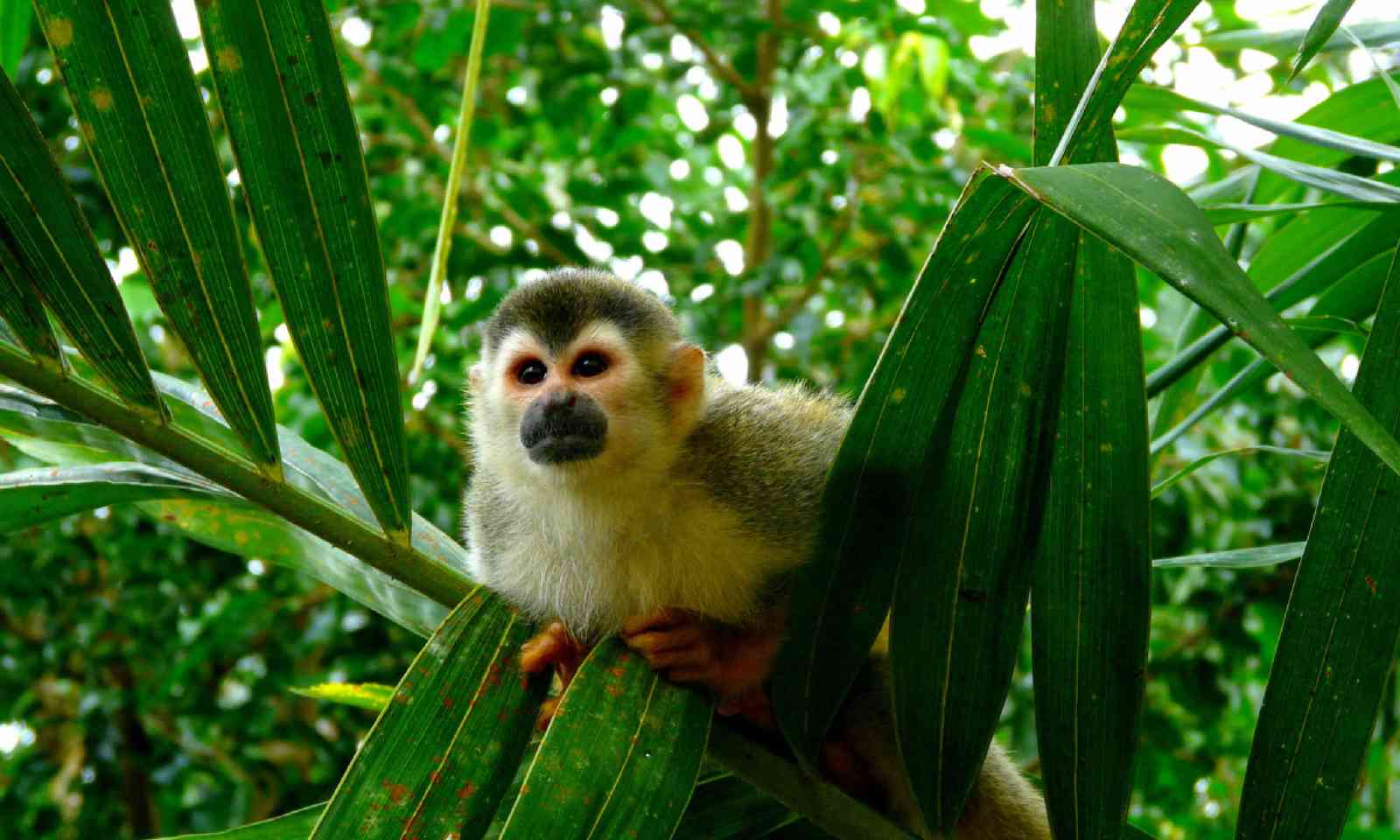
Squirrel monkey in Manuel Antonio National Park, Costa Rica (Shutterstock)
I can see why Costa Rica has won the hearts of so many gringo travellers. Every other person seems to be employed as a guide, English is widely spoken and a history of relative peace has made the Ticos – as Costa Ricans call themselves – very friendly. But years ago I’d read Graham Greene, who’d criticised the country for being boringly American and politically too sold out to US foreign policy; perhaps there was a blandness in the conversations here – especially after Nicaragua and El Salvador.
Panama City came as quite a shock. You see skyscrapers from a distance and then, suddenly, you’re on a high bridge over the canal; huge container vessels glided slowly beneath. I spent a night in the old city and then took a train across the well-preserved jungle corridor that borders the canal. The next day I came back by road and stopped at a park to see alligators, sloth, parrots, monkeys and dozens of tanagers and flycatchers.
I was now on the final straight of the northern Panamerican Highway. In theory the road runs for around 48,000km from Prudhoe Bay in Alaska to Ushuaia, at the southern tip of Tierra del Fuego in Argentina. But in Central America it comes to a halt when it meets the Darién rainforest.
I was quite glad to make it to Yaviza and find myself stopped by the Darién Gap. I’d clocked up at least 2,700km in two weeks. Had I gone too fast? Had I seen too little? I don’t think so. Because I wasn’t trying to get anywhere.
For me, a road signifies escape; I’m not really interested in its origin or its ending, only in its continuation. An ‘open’ road is like an open book, full of possibility. For a fortnight of freedom and fun, I’d put off decisions and crises, and indulged in the ultimate road movie – the scenes of everyday life and natural beauty flickered through the windscreen, always changing, always new.
The author travelled with Journey Latin America, which offers Alcion Journey, a 22-day group tour visiting Panama, Costa Rica, Nicaragua, El Salvador, Honduras and Guatemala.
Main image: The Pan-American Highway (Shutterstock)
The driver of the minibus to Guatemala City was careful and safety-minded. He slowed down on the tighter bends, used his gears to manage the steeper descents, and whistled meaningfully when two brightly painted buses shot by, one appearing to take a corner on two wheels.
I had a seat up front. I asked him why the chicken buses – the gringo nickname for the converted US school buses that dash around Guatemala – went so fast?
“They’re competing for passengers,” he said. “They each want to get to the next stop first so they can collect the fare.”
“Are there ever accidents?” I asked.
“Oh, lots,” he said. “They come off the road and fall down cliffs, they turn upside down, they crash head on.”
He said this as if it was a neutral observation. The rest of the time we chatted about the road improvements. The driver said the Taiwanese were responsible for the widening and landscaping of the highway, which was constantly beset by landslides during the rainy season.
A little later we noticed that one of the chicken buses had pulled over. Presumably it was the leader of the race. And of course, the loser had raced past to get to the next stop first. All for a few quetzals. It seemed like a rather absurd way to run public transport.
Then, we turned a corner, the clouds parted and there was a volcano – a mighty cone not 35km from the highway. It was Pacaya, smoking, still very much alive. A hiker in Antigua had told me you could feel the earth was hot beneath your feet in some places. “Have you climbed it?” I asked the driver. He laughed. “No way, too risky,” he said. “But not as risky as Guatemala City, where I’m dropping you off.”
Danger and death, geopolitics and geology, economic reality and natural beauty – nothing opens up a country like a road trip.
Guatemala
I was travelling down the Carretera Panamericana – the Panamerican Highway – through the nations of Central America. My starting point: Antigua, Guatemala. My destination: somewhere in Panama (I still hadn’t decided exactly where). The distance: at least 2,400km, though probably a lot more with a few detours. My purpose: none whatsoever, except to keep moving, look out the window, observe, and enjoy myself.The first leg, through the Guatemalan highlands, was a classic Latin American combination of distant drama – not only Pacaya but the even more impressive Agua and Fuego volcanoes – and chaotic, colourful towns hugging the roadside. Densely forested mountains and rich farmlands filled the spaces in between.

Colourful colonial buildings in Antigua, Guatemala (Shutterstock)
Soon I was deep inside the sprawl of Guatemala City, an ideal place to see through a bus window. Drab suburbs and manic markets can fascinate at a safe remove. At the main terminal I hopped on a bus heading south through a region cultivated with maize, wheat, coffee and sugarcane plantations. Barberena and Cuilapa looked like thriving agricultural towns, farmers trucks coming and going, street vendors jostling for space. Tourism so often thrusts travellers into curated places, but being on the road you see the lot.
El Salvador
I could feel the mountains and volcanoes pressing in as soon as I crossed the border into El Salvador. It’s the most seismic country I’ve ever visited and seems to pack as many mountains as it can into its small size. As well as a chain of cone-shaped volcanoes – around which the great highway winds – there are crater lakes on both sides, some of them huge and beautiful.The highway was heavy with lorries carrying fuel, food, scrap metal for recycling, cattle. Because everyone works along or just off this road, the soft-shoulders and verges were throbbing with men carrying machetes and coffee beans, fruit stalls, coconut vendors, school kids, bicycles and tuk-tuks, pickups and even the odd donkey. I saw some men selling live iguanas, illegally, holding the panic-stricken lizards by their tails.
I had a private guide in El Salvador, and a chance to see a bit more of the country. We spent a night at El Imposible, a national park named for its terrifying chasm, down which passing pack animals and muleteers would frequently fall to their certain death. I went birding at dusk and dawn and saw a mottled owl and a rare white hawk, before rejoining the highway to the capital.
San Salvador was a sprawl of a city, visibly Americanised in its layout, fast-food outlets and strip malls. I saw the huge mural in front of the main gallery, known as the Monument to the Revolution, commemorating the 1948 uprising that toppled President Salvador Castaneda Castro. With the Quetzaltepec volcano looming above, it was a dramatic enough setting – but I don’t go to Latin America for Burger Kings.

Street food in El Salvador (Shutterstock)
Suchitoto was far more my size of city. It has plenty of colonial buildings, and the plaza was a busy social spot with a funfair by day and fireworks at night. After a few beers, I watched as local men ran around wearing horse-shaped frames that were adorned with rockets and Catherine wheels. They chased girls and kids and basically ‘shot’ them with small explosives. It was hilarious – in a ‘this-could-go-horribly-wrong’ sort of way.
With my guide, we re-joined the Panamericana for the five-hour ride to Perquín, the operational base of many of the guerrillas who fought in the Civil War of 1979-1992. All Central America’s countries have seen strife of one kind or another, but El Salvador lost as many as 80,000 people in its proxy war. The village of El Mozote, in the north-eastern highlands of the country, was the site of the worst single massacre of the civil war. Some 1,000 civilians were killed, and only 450 or so have been accounted for; many of the slain were children.
I happened to be in town for the interment of some recently discovered remains. The procession was moving and there were moments of real beauty, with folksong, a children’s choir, and some uncompromising words from a local priest.
Honduras & Nicaragua
Honduras has only a short section of the Panamericana. While it is largely uneventful, I did catch a mellow, shrimpcoloured sunset over the Gulf of Fonseca – a stretch of water that provides Honduras with a port on the Pacific.The land seemed to open out wondrously in Nicaragua. Here the volcanoes were far away and huge tracts of dead-flat farmland flanked the roadside. Tobacco, banana, sorghum and pineapple were planted everywhere; people dried coffee beans out on the pavement or even the road – traffic is rarely heavy off the main highway.
On Ometepe, an island in Lake Nicaragua, I got to taste the spoils – and it was the most aromatic cup of coffee I’ve ever woken up to. It powered me up a serious hike, a real knee-wobbler up a rocky track to the top of the Maderas volcano. Sadly it was cloudy on top, but there were dozens of hummingbirds whistling around the cool mist to compensate.
Staying at an ecolodge lower down the slopes, I had time to reflect. I was loving my drives and rides in buses and taxis and rented cars. But why? What is it about roads, especially long ones? The USA invented the road movie but Central America has as much right to own the idea now. Its roads run through wilder places; its iconography is still waiting to be deciphered. Settlement across Latin America, from farms to fruit stalls to gas stations, has largely been along the roadside.
If you want leisure, then head for the parks. But if you like to see real life, then spend some time on the road.

Horse carts in Granada, Nicaragua (Shutterstock)
My next drives took me to Nicaragua’s three main cities. Managua has the greenery – a pretty if sad consequence of the 1972 earthquake that razed the city – but León and Granada are the two essential stops.
Both cities boast old, low-slung architecture and are rich in history. León is proud of its revolutionary connections, and murals cover the city. Here, church bells ring over idealised images of beret-sporting Sandinista guerrillas and anti-American slogans.
Granada, to the south, is quainter, with the lake lapping its edges. I was struck by the happy mix of language students and old timers, and the central plaza was crazily busy with fiestas, street-food vendors, musicians, marches, cyclists and nuns – the cathedral was being consecrated and bishops from all over were in town for the big occasion.
Journeying out to some islets in Lake Nicaragua, I had my first total disconnection. No roads, no noise, no tourists, no plaza. I swam in the lake – reassured that the local sharks never came to the shallows – and dined on exquisite ceviches and fish dishes in a remarkable hotel built partly from the rescued remnants of 1998’s devastating Hurricane Mitch.
Costa Rica
I’d expected the Panamericana to be smooth and wide and neat in Costa Rica, where I swapped a driver and car for my own small 4WD. It is, after all, a country stable and wealthy enough to have become an expat haven for Americans as well as the self-styled adventure tourism Mecca of the region. Perhaps the volcanoes got in the way, though. The road was pocked, pitted, and very bendy too, finding its way through the seismic contours of this breathtakingly beautiful land.A lot of tourism in Costa Rica focuses on the two coasts. The Panamericana takes you through the heart of the country, where you’re as likely to explore human culture as that of birds and beasts. At the Rincón de la Vieja National Park I had a great day out with a vaquero (cowboy). We rode across the slopes of the park’s namesake volcano, which was wrapped in a dense forest and topped by threatening rain clouds. Under the pre-storm light the vegetation glowed a strange lime green.
Back on the road, distances between stops were quite small but steep climbs and switchbacks slowed things down. I detoured from the main route to stay at another volcano – Arenal – where I hired a bike to cycle on an easy track at its base before speeding up to get to some hot springs before nightfall. I could see bright-orange lava flows at the top of the volcano from my lodge, at least until a massive storm lit up the sky.

Squirrel monkey in Manuel Antonio National Park, Costa Rica (Shutterstock)
I can see why Costa Rica has won the hearts of so many gringo travellers. Every other person seems to be employed as a guide, English is widely spoken and a history of relative peace has made the Ticos – as Costa Ricans call themselves – very friendly. But years ago I’d read Graham Greene, who’d criticised the country for being boringly American and politically too sold out to US foreign policy; perhaps there was a blandness in the conversations here – especially after Nicaragua and El Salvador.
Panama
Panama’s slender canal is its most famous feature, but the nation is long and sharply curved, such that it places Atlantic waters in the west and Pacific seas in the east. Back on a bus, I looked out on to grazing cattle and miles of root crops and fruit plantations. On breaks I could feel the prickle of the humidity; the mercury was nudging 30°C. But beyond were always bottle-green mountains, suggesting the southern highlands of Panama are well watered.Panama City came as quite a shock. You see skyscrapers from a distance and then, suddenly, you’re on a high bridge over the canal; huge container vessels glided slowly beneath. I spent a night in the old city and then took a train across the well-preserved jungle corridor that borders the canal. The next day I came back by road and stopped at a park to see alligators, sloth, parrots, monkeys and dozens of tanagers and flycatchers.
I was now on the final straight of the northern Panamerican Highway. In theory the road runs for around 48,000km from Prudhoe Bay in Alaska to Ushuaia, at the southern tip of Tierra del Fuego in Argentina. But in Central America it comes to a halt when it meets the Darién rainforest.
I was quite glad to make it to Yaviza and find myself stopped by the Darién Gap. I’d clocked up at least 2,700km in two weeks. Had I gone too fast? Had I seen too little? I don’t think so. Because I wasn’t trying to get anywhere.
For me, a road signifies escape; I’m not really interested in its origin or its ending, only in its continuation. An ‘open’ road is like an open book, full of possibility. For a fortnight of freedom and fun, I’d put off decisions and crises, and indulged in the ultimate road movie – the scenes of everyday life and natural beauty flickered through the windscreen, always changing, always new.
The author travelled with Journey Latin America, which offers Alcion Journey, a 22-day group tour visiting Panama, Costa Rica, Nicaragua, El Salvador, Honduras and Guatemala.
Main image: The Pan-American Highway (Shutterstock)
